Have you ever opened a weather app, seen a colorful radar map, and wondered what all those greens, yellows, and reds actually mean? You’re not alone.
Weather radar maps look technical at first glance—but once you understand the basics, they become one of the most powerful tools for tracking rain and storms in real time.
This beginner-friendly guide will walk you step-by-step through how to read a weather radar map, what the colors mean, how to track storm movement, and how to avoid common mistakes.
What Is a Weather Radar?
Weather radar (commonly called Doppler radar) is a system that sends out radio waves into the atmosphere. When those waves hit precipitation—like rain, snow, sleet, or hail—they bounce back to the radar station. The radar then analyzes:
-
📍 Location of precipitation
-
🌧️ Intensity (how heavy it is)
-
🌬️ Movement and wind patterns (in advanced radar modes)
Radar does not detect clouds directly. It detects precipitation particles.
That’s an important distinction many beginners miss.
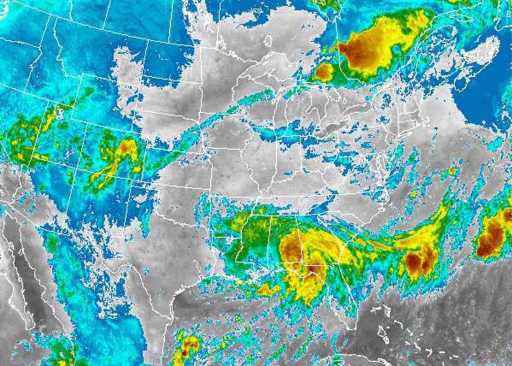
Understanding Radar Colors (The Most Important Part)
The color scale (also called the legend) is the key to reading radar properly.
Although colors may vary slightly by app or country, most radar maps follow this general pattern:
🌧️ Standard Radar Color Guide
-
Light Green → Very light rain or drizzle
-
Dark Green → Steady light rain
-
Yellow → Moderate rain
-
Orange → Heavy rain
-
Red → Very heavy rain / intense thunderstorms
-
Purple or Pink → Extremely intense storms or hail (on some scales)
The rule is simple:
The warmer and darker the color, the heavier the precipitation.
If you see bright red or purple, conditions could be intense—but that doesn’t automatically mean severe weather warnings are in effect. Always check alerts separately.
What Does “Reflectivity” Mean?
Most radar maps show something called reflectivity.
Reflectivity measures how much of the radar signal bounces back. Bigger raindrops or hailstones reflect more energy, which shows up as stronger colors (like red or purple).
-
Light rain = low reflectivity
-
Heavy downpour = high reflectivity
Think of reflectivity as the radar’s way of measuring how “thick” the rain is.
How to Read Storm Shapes on Radar
Radar maps aren’t just about color—the shapes matter too.
1️⃣ Large, Widespread Areas
A broad, consistent area of green or yellow often means steady rain from a larger weather system.
This type of rain usually lasts longer but may not be intense.
2️⃣ Small, Circular Blobs
Small, intense cells (often yellow, orange, or red) usually indicate thunderstorms.
These storms:
-
Form quickly
-
Can bring heavy rain
-
May include lightning or strong winds
3️⃣ Lines of Storms
If storms appear in a straight or slightly curved line, it may be a squall line.
Squall lines often bring:
-
Strong winds
-
Sudden heavy rain
-
Possible severe weather
4️⃣ Hook-Shaped Patterns
In certain regions, a hook-like shape on radar can indicate a rotating storm.
While rare in many areas, in tornado-prone regions this pattern can signal potential tornado activity.
Beginners don’t need to master advanced storm spotting—but recognizing patterns improves your radar-reading confidence.
How to Track Storm Movement (The Radar Loop)
A single radar image shows only one moment in time.
To truly understand what’s happening, you need to use the radar loop feature (usually a play button in weather apps).
Watch at least a 30–60 minute loop to see:
-
Direction of movement
-
Speed of the system
-
Whether storms are strengthening or weakening
How to Interpret Movement
-
Moving toward your location → Rain likely soon
-
Moving away → Conditions improving
-
Slow-moving system → Prolonged rainfall
-
Rapidly developing cells → Possible storm intensification
Motion is just as important as intensity.
Radar vs Weather Forecast: Know the Difference
Many beginners confuse radar with forecasts.
Here’s the difference:
📡 Radar
Shows what is happening right now (or within the last few minutes).
Best for:
-
Short-term planning (next 1–3 hours)
-
Deciding when to leave the house
-
Tracking approaching storms
📊 Forecast
Predicts what may happen later based on models and meteorology.
Best for:
-
Planning days ahead
-
Event preparation
-
Travel decisions
Think of radar as real-time weather tracking, not future prediction.
Common Mistakes Beginners Make
Let’s clear up a few common misunderstandings.
❌ Mistake 1: Assuming Red Means Severe Weather
Red means heavy precipitation, not necessarily a severe storm warning.
Always check official alerts separately.
❌ Mistake 2: Ignoring the Timestamp
Radar images may be several minutes old. Always check the timestamp before making decisions.
❌ Mistake 3: Confusing Radar With Clouds
Radar shows precipitation—not cloud cover.
A cloudy sky won’t show on radar unless it’s producing rain.
❌ Mistake 4: Not Watching the Loop
A static radar image doesn’t tell you where the storm is going.
Movement matters.
What Radar Can’t Tell You
Weather radar is powerful—but it has limits.
Radar does not:
-
Show temperature
-
Detect fog accurately
-
Predict long-term weather
-
Always detect very light drizzle
It also may not perfectly estimate snowfall intensity in winter storms.
Understanding these limits helps you use radar more effectively.
Beginner-Friendly Radar Reading Strategy
If you want a simple step-by-step approach, follow this:
-
Check the timestamp
-
Look at the color legend
-
Identify your location
-
Zoom out to see the bigger weather system
-
Watch the radar loop
-
Check official weather alerts
That’s it.
No meteorology degree required.
Why Learning Radar Is Useful
Reading radar maps can help you:
-
Plan outdoor events
-
Avoid getting caught in heavy rain
-
Time your commute
-
Track storm progress
-
Make safer travel decisions
It’s especially helpful in regions with fast-changing weather.
Final Thoughts
Weather radar maps may look complicated at first—but they’re simply real-time precipitation maps with color-coded intensity.
Once you understand:
-
What the colors represent
-
How storm shapes matter
-
Why motion is important
-
The difference between radar and forecast
—you’ll be able to read radar maps confidently and make smarter weather decisions.
The next time you open your weather app, you won’t just see colors—you’ll understand the story the atmosphere is telling.
Frequently Asked Questions (FAQ)
1. What do the different colors on weather radar mean?
Colors represent precipitation intensity. Green indicates light rain, yellow moderate rain, orange heavy rain, and red very heavy rain. Purple may indicate extreme intensity or hail.
2. Does red on radar always mean severe weather?
No. Red indicates heavy precipitation, not necessarily severe weather. Always check official weather warnings separately.
3. How far ahead can radar predict weather?
Radar does not predict weather. It shows current conditions. However, by watching movement, you can estimate what may happen in the next 1–3 hours.
4. Why does rain sometimes disappear on radar?
This can happen due to radar limitations, storm weakening, or distance from the radar station.
5. Can radar detect snow?
Yes. Radar can detect snow, but intensity estimates may not always be as accurate as rain measurements.
6. What is Doppler radar?
Doppler radar is an advanced radar system that can detect wind movement and rotation in addition to precipitation.
7. Why does radar sometimes look blurry or pixelated?
Radar images are created from reflected signals. Distance from the radar station and signal strength can affect image clarity.