Weather satellites play a crucial role in monitoring and predicting storms across the globe. From hurricanes over the Atlantic Ocean to typhoons in the Pacific and severe thunderstorms over land, satellites provide meteorologists with the real-time data needed to understand and forecast weather patterns. Without these advanced technologies orbiting Earth, accurate weather forecasting and early storm warnings would be nearly impossible.
In this guide, we’ll explore how weather satellites work, the different types used in forecasting, and how they help scientists track storms as they develop and move across the planet.
What Are Weather Satellites?
Weather satellites are specialized satellites designed to observe Earth’s atmosphere, oceans, and cloud patterns from space. These satellites continuously capture images and collect data about weather systems, helping meteorologists monitor storms, measure atmospheric conditions, and improve weather predictions.
Unlike ground-based weather stations, satellites can observe large areas of the planet at once, including remote oceans and regions with limited monitoring equipment. Since most major storms develop over oceans, satellites are essential for early detection.
Weather satellites typically orbit Earth at very high altitudes and use advanced sensors and cameras to gather information about:
-
Cloud formation and movement
-
Storm intensity and structure
-
Temperature patterns
-
Atmospheric moisture levels
-
Wind speeds and directions
This data is transmitted to meteorological centers around the world, where it is analyzed and used to produce weather forecasts and storm warnings.
Types of Weather Satellites
There are two main types of weather satellites used in storm tracking: geostationary satellites and polar-orbiting satellites.
1. Geostationary Satellites
Geostationary satellites orbit Earth at approximately 36,000 kilometers above the equator. At this altitude, the satellite moves at the same speed as Earth’s rotation, which allows it to remain fixed over one specific location.
This unique position enables the satellite to continuously monitor the same region of the planet. Meteorologists use these satellites to track the development and movement of storms in real time.
Key advantages of geostationary satellites include:
-
Continuous observation of the same weather system
-
Real-time monitoring of hurricanes and cyclones
-
Frequent image updates every few minutes
Because of their constant monitoring ability, geostationary satellites are especially useful for tracking fast-changing weather events such as thunderstorms and tropical storms.
2. Polar-Orbiting Satellites
Polar-orbiting satellites travel around Earth from pole to pole at a much lower altitude, typically around 800–850 kilometers above the surface.
As Earth rotates beneath the satellite’s orbit, the satellite eventually scans the entire planet. This allows meteorologists to collect highly detailed atmospheric data from every region of Earth.
Polar satellites are particularly useful for:
-
Measuring atmospheric temperatures
-
Monitoring sea surface temperatures
-
Tracking ice coverage in polar regions
-
Detecting storm structures in detail
Although they do not continuously observe one area like geostationary satellites, their high-resolution data is extremely valuable for improving global weather models.
How Satellites Detect Storm Formation
Storms typically form when warm air rises and interacts with cooler air in the atmosphere. Weather satellites detect the early stages of storm formation by observing changes in cloud patterns and atmospheric conditions.
Satellite sensors monitor:
-
Cloud height and thickness
-
Temperature differences in the atmosphere
-
Moisture levels in storm systems
When meteorologists see clusters of rapidly growing clouds or organized rotating systems, they can identify the early signs of storms such as hurricanes or tropical cyclones.
By tracking these patterns over time, satellites help forecasters determine whether a storm is strengthening, weakening, or changing direction.
Satellite Imaging Technology
Weather satellites use several advanced imaging technologies to monitor storms.
Visible Light Imaging
Visible satellites capture images similar to what the human eye would see from space. These images show cloud patterns and storm shapes during daylight hours.
However, visible imaging cannot detect storms at night.
Infrared Imaging
Infrared sensors measure the temperature of clouds and the Earth’s surface. Since colder cloud tops usually indicate stronger storms, infrared imaging helps meteorologists identify powerful storm systems.
Infrared technology also works both day and night, making it essential for continuous storm tracking.
Water Vapor Imaging
Water vapor imagery detects moisture in the atmosphere. This allows meteorologists to see how moisture moves within the atmosphere and identify developing weather systems that may produce storms.
This imaging technique is especially useful for tracking jet streams and atmospheric circulation patterns.
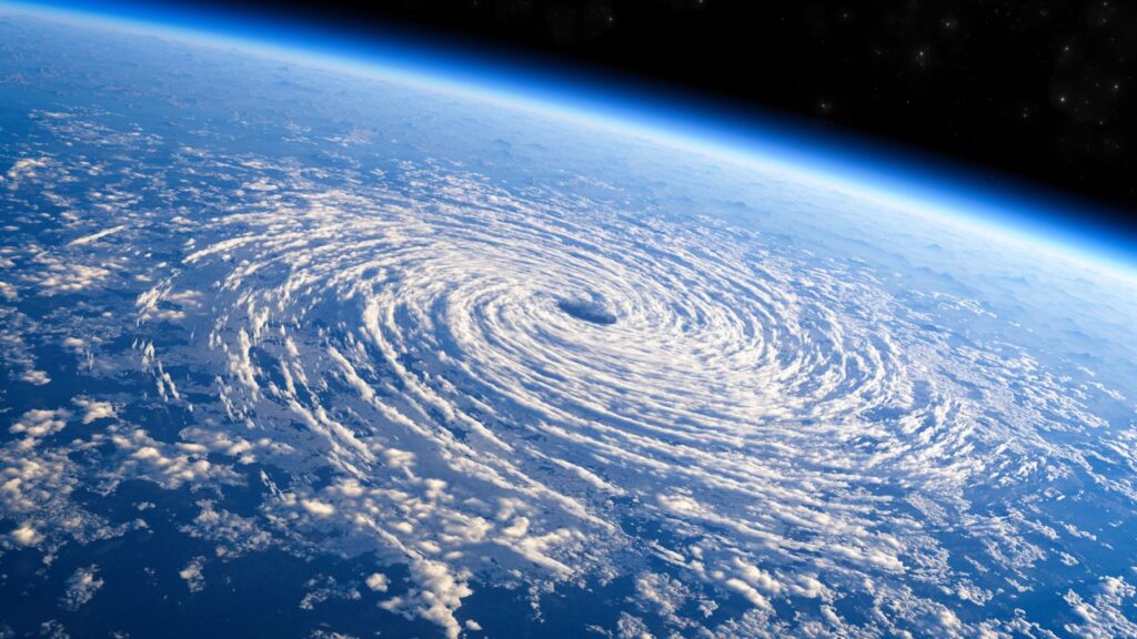
Tracking Hurricanes and Cyclones
One of the most important roles of weather satellites is monitoring hurricanes, cyclones, and typhoons. These massive storm systems can cause severe damage, flooding, and loss of life if they are not predicted early.
Satellites help meteorologists track these storms by:
-
Monitoring storm eye formation
-
Measuring cloud top temperatures
-
Tracking storm movement across oceans
-
Estimating wind speed and rainfall intensity
Using satellite data, meteorologists can predict the path of hurricanes days before they reach land. This allows governments to issue evacuation orders and prepare emergency responses.
How Satellite Data Improves Weather Forecasting
Satellite observations are fed into powerful computer models that simulate atmospheric behavior. These models analyze billions of data points from satellites, weather stations, and ocean sensors to predict future weather conditions.
The benefits of satellite data include:
-
More accurate storm forecasts
-
Earlier warnings for severe weather
-
Improved climate monitoring
-
Better understanding of global weather patterns
Thanks to satellite technology, modern weather forecasting has become significantly more accurate than it was just a few decades ago.
Future Innovations in Weather Satellites
Weather satellite technology continues to evolve as scientists develop more advanced monitoring systems.
Future improvements may include:
-
Higher-resolution satellite imagery
-
Faster data transmission to forecasting centers
-
Artificial intelligence to analyze weather patterns
-
Improved sensors for detecting atmospheric changes
These innovations will allow meteorologists to track storms more precisely and issue earlier warnings, helping protect communities around the world.
Conclusion
Weather satellites have revolutionized how scientists observe and understand storms. By capturing detailed images and atmospheric data from space, these satellites provide meteorologists with the tools needed to monitor storm development, track their movement, and forecast severe weather events.
From hurricanes and typhoons to thunderstorms and cyclones, satellite technology plays a vital role in protecting lives and improving weather prediction accuracy. As technology continues to advance, weather satellites will become even more powerful in helping scientists understand Earth’s complex atmospheric systems.
FAQs
1. How do weather satellites help predict storms?
Weather satellites monitor cloud formations, temperature patterns, and atmospheric moisture. This data helps meteorologists detect developing storms and forecast their movement.
2. What are the two main types of weather satellites?
The two main types are geostationary satellites, which stay fixed over one area, and polar-orbiting satellites, which scan the entire planet as they orbit Earth.
3. Can satellites track hurricanes in real time?
Yes. Geostationary satellites continuously monitor hurricanes and update images every few minutes, allowing meteorologists to track storm intensity and direction.
4. Do weather satellites work at night?
Yes. Infrared satellite sensors can detect storms at night by measuring cloud temperatures.
5. Why are weather satellites important?
Weather satellites provide global weather monitoring, improve forecast accuracy, and help issue early warnings for dangerous storms, reducing damage and saving lives.