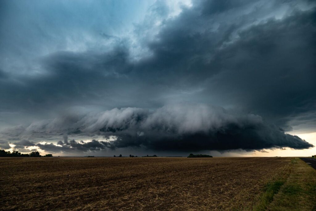
Weather systems can range from gentle rain showers to powerful storms capable of causing severe destruction. Among the most dangerous storm types is the supercell storm, a rare but extremely powerful thunderstorm known for producing tornadoes, giant hail, intense lightning, and destructive winds.
Supercells are considered the most severe form of thunderstorm because they have a unique rotating structure that allows them to persist longer and grow stronger than ordinary storms. Understanding how supercell storms form and why they are dangerous can help people recognize warning signs and stay safe during extreme weather conditions.
What Is a Supercell Storm?
A supercell storm is a type of thunderstorm that contains a deep and persistent rotating updraft, known as a mesocyclone. This rotating column of rising air gives the storm its distinctive structure and allows it to last much longer than typical thunderstorms.
Unlike regular storms that usually dissipate within an hour, supercell storms can last for several hours and travel hundreds of kilometers while maintaining their strength.
Supercells are known for producing some of the most severe weather events on Earth, including:
-
Tornadoes
-
Large hailstones
-
Damaging straight-line winds
-
Flash flooding
-
Intense lightning
These storms are most commonly observed in regions with unstable atmospheric conditions, such as parts of the United States, India, Bangladesh, and Australia.
Key Features of a Supercell Storm
Supercell thunderstorms have several unique characteristics that distinguish them from other storm types.
Rotating Updraft (Mesocyclone)
The most important feature of a supercell is the mesocyclone, a rotating column of air within the storm. This rotation forms when wind speeds and directions change with height, a phenomenon called wind shear.
This rotation allows the storm to organize itself and maintain strength for long periods.
Anvil-Shaped Cloud
Supercells typically produce a large anvil-shaped cloud at the top of the storm. This occurs when rising air reaches the upper atmosphere and spreads outward.
This anvil can stretch for hundreds of kilometers and often signals a powerful storm system.
Wall Cloud
A wall cloud sometimes forms beneath the storm’s main updraft. This lowering cloud base is often where tornadoes develop.
Spotting a rotating wall cloud is often considered an early warning sign of possible tornado formation.
Heavy Rain and Lightning
Supercells can produce extremely heavy rainfall along with intense lightning activity. These conditions can lead to flash floods and dangerous visibility conditions.
How Do Supercell Storms Form?
Supercell storms require a specific combination of atmospheric conditions. Meteorologists typically identify three main ingredients needed for their formation.
1. Atmospheric Instability
Instability occurs when warm, moist air near the surface rises into cooler air above. This rising air fuels powerful updrafts that help thunderstorms develop.
2. Wind Shear
Wind shear refers to changes in wind speed or direction with height in the atmosphere. Strong wind shear allows thunderstorms to develop rotation, which is essential for supercell formation.
3. Moisture
Moist air provides the fuel for storm development. When moisture combines with unstable air and wind shear, conditions become ideal for severe thunderstorms.
When these three ingredients come together, they can produce a rotating thunderstorm capable of becoming a supercell.
Why Are Supercell Storms So Dangerous?
Supercell storms are considered dangerous because they can produce multiple extreme weather hazards at the same time. Unlike normal thunderstorms, which may cause only heavy rain or lightning, supercells often produce several destructive elements simultaneously.
Tornado Formation
Supercells are responsible for most of the strongest tornadoes recorded worldwide. The rotating updraft inside the storm can tighten and stretch downward, eventually forming a tornado.
Some tornadoes generated by supercells can reach wind speeds exceeding 300 km/h, capable of destroying buildings and uprooting trees.
Giant Hail
Supercells can produce unusually large hailstones because the strong rotating updraft keeps hail suspended in the storm longer, allowing it to grow.
In extreme cases, hailstones can become as large as baseballs or even larger, causing severe damage to vehicles, crops, and buildings.
Damaging Winds
Powerful downdrafts inside supercell storms can produce destructive straight-line winds exceeding 100 km/h. These winds can knock down trees, damage roofs, and disrupt power lines.
Flash Flooding
Because supercells can produce extremely heavy rainfall in a short period, they can trigger flash floods, especially in urban areas or mountainous regions.
Types of Supercell Storms
Meteorologists classify supercells into several types depending on their precipitation patterns and structure.
Classic Supercell
This is the most recognizable type of supercell. It has a clear rotating structure and often produces tornadoes, hail, and heavy rain.
High-Precipitation Supercell
These storms produce large amounts of rain, which can obscure tornadoes and make them difficult to see.
Low-Precipitation Supercell
Low-precipitation supercells produce less rainfall but can still generate strong tornadoes and damaging winds.
Where Do Supercell Storms Occur?
Supercell storms can form anywhere in the world where atmospheric conditions are favorable, but they are most common in certain regions.
Some of the most active regions include:
-
Central United States (often called Tornado Alley)
-
Northern India and Bangladesh
-
Parts of Australia
-
Argentina and southern Brazil
In India, supercell storms are sometimes observed during pre-monsoon months, especially in eastern and northern regions.
Warning Signs of a Supercell Storm
Although meteorologists rely on radar and satellite technology to detect supercells, there are several visual warning signs people may notice.
These include:
-
Large, rotating cloud formations
-
A dark, greenish sky
-
A lowering wall cloud beneath the storm
-
Frequent lightning and thunder
-
Large hail falling from the sky
If these signs appear, it is important to seek shelter immediately.
Safety Tips During a Supercell Storm
Because supercell storms can develop rapidly, preparation and quick action are essential.
Here are some important safety tips:
Stay indoors: Move inside a sturdy building and avoid windows.
Go to a lower level: Basements or interior rooms provide the best protection.
Avoid driving: Strong winds, hail, and poor visibility can make travel extremely dangerous.
Monitor weather alerts: Pay attention to official weather warnings and emergency notifications.
Prepare emergency supplies: Keep flashlights, water, and a battery-powered radio available during severe storms.
Conclusion
Supercell storms are among the most powerful and dangerous weather systems on Earth. Their rotating structure allows them to produce severe weather events such as tornadoes, giant hail, destructive winds, and flash floods.
Although these storms are relatively rare compared to ordinary thunderstorms, they can cause widespread damage and pose serious risks to life and property. Understanding how supercells form, recognizing warning signs, and following safety precautions can help reduce the impact of these extreme weather events.
As weather forecasting technology continues to improve, meteorologists are becoming better at predicting supercell storms and issuing timely warnings. Staying informed and prepared is the best way to stay safe when severe weather strikes.
Frequently Asked Questions (FAQs)
What makes a supercell storm different from a normal thunderstorm?
A supercell storm contains a rotating updraft called a mesocyclone, which allows the storm to last longer and produce more severe weather than regular thunderstorms.
Can supercell storms produce tornadoes?
Yes. Supercells are responsible for most powerful tornadoes, especially in regions with strong atmospheric instability and wind shear.
How long do supercell storms last?
Unlike normal thunderstorms that last about 30–60 minutes, supercell storms can persist for several hours and travel long distances.
Are supercell storms common in India?
Supercell storms are less common than ordinary thunderstorms in India but can occur during the pre-monsoon season, particularly in northern and eastern regions.
How can you stay safe during a supercell storm?
The best safety steps include staying indoors, avoiding windows, monitoring weather alerts, and moving to a basement or interior room if possible.